Showing posts with label Winant. Show all posts

28 August 2015

Genealogy of Almedia Branham

The genealogical information from your DNA can be helpful and sometimes it can be a killer.  Recently, through DNA testing, I realized that my biological great grandfather was most likely not James William Brubaker, but instead was Robert Lee Minton.  My DNA markers indicate that I am descended from Robert Minton, as I have multiple DNA matches to the Minton line and no direct DNA matches to the Brubaker line. This breathes life into the old family joke that my grandmother and her twin might be Mintons instead of Brubakers.

Courtesy of Pam Kerschner
My great grandmother, Almedia Branham, disappeared shortly after my grandmother, Kathleen Brubaker and her twin sister, Katherine, were born.  She left behind her husband, James William "Bill" Brubaker and nine children.  After their mother's disappearance, Kathleen and Katherine lived with their grandmother, Margaret, until her death in 1922. Then they may have stayed with one of their married siblings before coming to live with their father, James Brubaker and Roxi (Smith) Prince. (As a side note; the twins were named Elizabeth and Loretta at birth, and their older siblings changed the girls' names to Kathleen and Katherine to be more "twin"-like.) Sadly, the girls died without knowing what had happened to their mother.

http://www.nps.gov/neri/learn/historyculture/prince.htm
My cousin, Pam, is an amazing family genealogist.  She pored through census records, historical documents,  and old phone books; wrote letters, made telephone calls,visited courthouses, interviewed family members, and conducted endless internet searches. During an interview with family members, she learned that Robert Minton was seen boarding a train in Prince, WV, but Almedia was not with him.  However, woman's intuition made her wonder if they had run off together, and she eagerly awaited the 1930 census data release.

After 72 years, United States Census records are released to the public by the National Archives and Records Administration. In accordance with the 72-Year Rule, the National Archives released the 1930 records in April 2002 and most recently, the 1940 records were released April 2, 2012.  https://www.census.gov

When the census was finally released, she was able to find that Almedia and Robert had been living as husband and wife in California. There, she gave birth to another set of twins (a boy and a girl) and raised her new family.  She died in California and was buried there, as "Madie Minton." From our understanding, she never contacted her family here in WV.  However, Robert Lee Minton, was suspected to have stayed in contact with his family.

Unfortunately, Almedia's California twins were both deceased before the family line was traced.  We hope to locate more information and photographs about her, and now with the knowledge that my grandmother was a Minton, about Robert Minton too. We continue to search for the ancestors of James William Brubaker, he is still a family roadblock. Regardless of the genetics, since he raised her, he was my grandmother's father and my great grandfather.
Katherine and Kathleen

As a family genealogist, you learn quickly not to judge your ancestors.  We do not have knowledge of why events occurred.  We search for the factual information about our family's branches. You need to be thick-skinned and ask the difficult questions, be honest with your own responses, and embrace the cousins you may inherit.

Almedia Branham Timeline

Almedia was the child of Melvin Branham and Margaret Wright. She was born in Wise County, Virginia on 19 Nov 1878.

In the 1880 census, she lived with her mother, Margaret Wright, and grandmother, Surrilda (Austin) Wright

In 1895, she married Edward Myers.  Edward Myers abandoned her (see our Edward Myers blog) and she was granted a divorce, 3 July 1903.  [Order of Publication, Wise County, Virginia]

In the 1900 census, she is listed in her mother's household, along with her two children, Alfred and Ethel.

In 1903 she married J. W. Brubaker in Wise county, VA.  [Virginia Select marriages, 1785-1940]

In the 1910 census, she lived in the town or Raleigh, WV with William J Brubaker, and four children, Ethel, Myrtle, Ernest, and Ossie.  Alfred was reported by family history to have died at the age of eight of diphtheria.

In the 1920 census, she lived with William Brubaker in Shady Spring,WV with children, Myrtle, Everett (Earnest) Margaret (Ossie), Alice, Robert, James, and Buster (Charles).  Interesting to note, her mother was listed as Margaret Minton who was living with her husband, Robert L. Minton, next door. Robert's two sons from a previous marriage, George and Walter, were living with Robert and Margaret.

On 26 June 1920, while living in Glen Morgan, Almedia Branham Brubaker bore two more children, my grandmother and her twin sister.

Then on 13 Nov 1921, Almedia Branham Minton of Glenburn, Shasta County, CA bore twins to Robert Minton.  [California Birth Index]

In the 1930 census, she lived in Squaw Valley, Siskiyou County, California, with husband Robert L. Minton, and two children, Cecil and Cleo.

In the 1940 census, she lived in Glenburn, Shasta County, California, with Robert and Cecil Minton

On 3 Mar 1955 she died in Redding, Shasta County, California.  As a side note, the death certificate states she was born in Virginia as Madia Branham, on 19 Nov 1878.  [California Death Index, 1940-1977] She was buried at Pine Grove Cemetery, McArthur, Shasta County, CA as Madia Minton.

Most of this research was completed by my cousin, Pam.  She has been a huge help to me as a family genealogist.

Note: Some of the records listed here were found under alternate spellings or nicknames:

  • Bruebaker for Brubaker
  • Meyers for Myers
  • Mintor for Minton
  • Alferd for Alfred
  • Almeeda, Media, Madie, Madia for Almedia.
  • Kathlene for Kathleen.
If you have any information about our Minton cousins please contact us. 

Ellison Ridge Road

Summers County, Ellison Ridge, and the Lillys

As we've shared before, when we have spare time we like to go looking for cemeteries. To add a specific tangible goal, we like to review the Find-A-Grave photo requests and pick out a hopeful target cemetery. Then we do some research on it (a little "digging" you might say) and then we go out and try to locate the cemetery and the requested grave markers.

David


We don't always find what we are looking for, but we always enjoy looking.

Recently, we decided to go looking for a Lilly Family Cemetery in Summers County. If you are from southern WV, you might realize how daunting that is.  Lilly is the most common surname in our area, far ahead of Smith and Jones and the rest. And from what I can tell the heart of Lilly country is around Jumping Branch and Nimitz in Summers County. Find-A-Grave lists a bunch of cemeteries in this area, most of them with "Lilly Family" in the name, and most of them with less than a hundred graves.

In other words, there are a bunch of Lillys, and many many small family cemeteries. A big task, indeed.

As a start, we made a list, and found that Find-A-Grave lists 18 cemeteries in Summers County all starting with the name Lilly. Now some may be duplicates, but still that's a bunch. So we noted as many directions and coordinates and descriptions as we could find and tried to organize them.

We found that four or five of the cemeteries seemed to be on Ellison Ridge Road. So we plotted out a map, and headed out to find them all. And as a specific goal, we wanted to find Clarice Lilly's grave, which was a Find-A-Grave request from our friend Ralph.

Before tackling Ellison Ridge, we made two other stops. First, we drove out Will Dodd Road in Jumping Branch, looking for a cemetery that was reported to be there, but we struck out. Then we went to Lilly-Crews, a large cemetery in Nimitz. This one is easy to find, well kept, and fairly large. Interestingly, it contains a number of graves that were relocated from a cemetery near the town of Lilly as the Bluestone Dam was being constructed. The old cemetery was flooded by what is now Bluestone Lake.

Finally, we headed out Ellison Ridge. We had rough directions to two cemeteries - the first was about 1.5 miles along on the left at the top of a hill. After we had gone about 3/4 mile, we saw chain-link fencing near an old burned-out sawmill, and visited the small cemeteries there. There were actually two fenced areas, joined together, with one smaller and one more dominant.
When we continued down Ellison Ridge we were looking for a cemetery up the hill from an old schoolhouse. We found this building here, and a cemetery above it, and were sure we had found it.


Just as at the other site, we found two separately fenced areas. We were excited, but were puzzled that we still couldn't find Clarice Lilly's marker. Nonetheless we photographed the lot, and decided it was time to be done for the day.


When we got home and looked carefully at our pictures and mapping, we realized that we had not found a Lilly Cemetery at all. The first two we found were the small Meader/Odie Cemetery and it's larger neighbor just named Meador Cemetery.

The two fenced areas near the "schoolhouse" turned out to be the Fall Rock Cemetery. Not only that, but all three cemeteries were already completely documented in Find-A-Grave. So we hadn't fulfilled a single photo request.

26 August 2015

Finding Life in a Cemetery

Sherry

While "working" a cemetery...digitizing headstones, uploading photo requests to Find-A-Grave. I find myself captivated by the life within the cemetery.  As David systematically digitizes headstones, I break off and begin photographing the beauty.

I explore the legends and spirituality behind the life I find in the cemetery.  Here are some of the photographs:

Bee Legend of the Appalachian Mountains

copyright, Slowmoto Graphics
In parts of the Appalachian mountains, there is a legend about bees surrounding a death in the family. Whenever someone dies, the family must whisper the information to the bees before the sunrise of the next day. The bees are the messengers of the gods and fly into the heavens and notify the Gods of the death.

If the family doesn't relay the information to the bees, the family living under the same roof of the deceased will perish.  In Ireland the folklore includes keeping the Gods informed of human events and inviting the bees to attend the funeral or turning the hives toward the path of the coffin's route. http://irishhedgerows.weebly.com


Tell the Bees

By Sarah Lindsay

Tell the bees. They require news of the house;
they must know, lest they sicken
from the gap between their ignorance and our grief.
Speak in a whisper. Tie a black swatch
to a stick and attach the stick to their hive.
From the fortress of casseroles and desserts
built in the kitchen these past few weeks
as though hunger were the enemy, remove
a slice of cake and lay it where they can
slowly draw it in, making a mournful sound.


copyright, Slowmoto Graphics

Butterfly Soul

In Ireland, there is a saying:  “Butterflies are souls of the dead waiting to pass through purgatory.” A butterfly begins its' life as a caterpillar then metamorphoses into a butterfly. The butterfly symbolizes resurrection and represents the soul leaving the body. https://mysendoff.com 

In Ancient Greek, the word butterfly is known as the psyche, which means soul.  The butterfly's soul is touched by divine love, but which, by reason of the mistakes made, must undergo some tribulations before having access to happy immortality. http://www.insects.org/


copyright, Slowmoto Graphics

Legend of the Butterfly

According to an American Indian Legend, if anyone desires a wish to come true they must first capture a butterfly and whisper that wish to it.  Since a butterfly can make no sound, the butterfly cannot reveal the wish to anyone but the Great Spirit who hears and sees all.
In gratitude for giving the beautiful butterfly its freedom, the Great Spirit always grants the wish. So, according to legend, by making a wish and giving the butterfly its freedom, the wish will be taken
to the heavens and be granted."  http://www.swallowtailfarms.com

I read many poems about butterflies and the afterlife before finding this poem:

  I AM NOT THERE


Do not stand by my grave and weep
For I am not there.

I do not sleep.
I am a thousand winds that blow.
I am diamonds that glint on snow.
I am the sunlight on ripened grain.
I am the gentle autumn rain.

When you awaken in the morning hush
I am the swift uplifting rush of butterflies in joyous flight.
I am the soft stars that shine at night.

Do not stand at my grave and cry.
I am not there.  I did not die.

Author Unknown


23 August 2015

Samuel Carter Cemetery - Part I

Location, Location, Location

Sherry unearthed twelve to fourteen Find-A-Grave photo requests for a "Dempsey Cemetery" which had accumulated multiple cemetery entries, each with the same name but different locations. Tangled among the requests was rhetoric about the exact location of the cemetery, members debating between Raleigh County and Fayette County as the most likely site. After reviewing the burial data and list of possible interments, a Fayette County location seemed reasonable, even with one entry proclaiming a Raleigh County burial.  The mystery heightened and the search for the "Dempsey Cemetery" began.

She found a note in Rootsweb which says:
Samuel Carter Cemetery on Dempsey Branch (Laurel Creek) behind Doggett Chapel, Fayette County, West Virginia
The ones we found in the database were:

One death certificate included in the search stated "Epperly Cemetery", which after a documentation review hinted to Kanawha County being a more likely spot.

We found coordinates for Doggett Chapel on an old list of churches:
https://www.google.com/maps/place/38°03'12.4"N+81°09'47.4"W/
and at least according to Google maps, the community of Dempsey is centered right across the street.

So our updated directions to the chapel are:
Take US-19 (N) to Fayetteville. Turn left on Laurel Creek Rd, Route 8. Go about 4 miles. Right where Rt 8 takes 110 degree right, stay straight on Dempsey Rd/Wriston Rd/Rt 81. The church should be 50 feet on left, and the cemetery hopefully nearby.
We found an opportunity to explore the whereabouts based on the data found.   Without error, we drove to the Doggett Chapel UMC, however when we scanned the area around the church  the cemetery wasn't in sight. We talked with a neighbor, and after securing his attention and letting him calm his guard dog, he said it was about 250 yards up a rutted road, but we couldn't get there in our truck.

Pinpointing the cemetery looked to be more involved than the original indication that the cemetery was behind the church.  We were in for a mountainous hike and would need a full day commitment.

Take Two

We set out Sunday to try again. The boys were reluctant to go until we explained the part about a hike in the woods. Our plan was to park at the bottom of the washed-out road, near the church, and walk up the 300 yards or so to the cemetery. Samuel asked how long it would take, and I estimated 5 minutes to get there.

At the 5 minute point, we got to a house, the one of which we had been told. One gentleman was outside with his dogs, and we talked to him. He said the cemetery was up at the end of the road. When we looked where he was pointing, we could see that the road we'd walked up kept on going, sort of, up the hill. At this point it was less of an old washed-out road and more of a couple ruts through the woods.
Road to Carter Cemetery


We went on a couple hundred more yards and came to a fence line and a gate, with pastureland on the other side. This was a venerable pasture, with large bushes and trees grown up in it, and out of sight from any houses or roads. And posted with No Trespassing signs we could not miss.

Feeling like America's Most Wanted, we climbed over the gate and kept following the road. It went up the west side of the pasture along the fence, and just kept gradually climbing up the hill. We didn't see any farm animals, but there was plenty of evidence of them on the path.

Sherry spied a likely spot for a cemetery off to the left of the trail, so she and Joseph went to investigate while Samuel and I continued following the fence line.

Sam and I passed a couple of gates in the fence on our right, and when the road started to go downhill a bit (in our experience, rarely are WV family cemeteries located in a valley), we thought we needed to return to the last gate we had passed, which had a promise of a short distance up to the summit.  So we scaled another gate, and followed what was now a deer trail through the brambles.

Sherry and Joe were unsuccessful in their pursuit and began backtracking. They report that they heard a bear knock over a rotted tree below them, and they hightailed it up the trail. They spotted the muddy footsteps on the gate that we scaled when we detoured off the main trail, so they were able to follow behind.

The trail widened back into a rutted track when it got to the trees, and we kept going with a little more confidence. We could see that some force of nature had felled some mighty big trees, and we had to scramble under one that blocked the path. Just after we crossed that obstacle, though, we saw a small clearing and some gravestones.  Success!

22 August 2015

Samuel Carter Cemetery - Part II

Combing Through The Trees

We were so relieved to actually find a cemetery after hiking what seemed like miles up the hill, we didn't even worry that it looked like only a few grave sites. The small clearing was very pretty anyway, and we could declare a victory. So we set out to photograph the stones.

Copyright 2014 Slowmoto Graphics
As we got up into the clearing more, we saw some huge stone pillars back in the trees. They looked like part of a gateway almost. A little surreal, like a scene from The Lion, The Witch and The Wardrobe. (Or at least the way I pictured the scenes reading the book as a child)  Joseph related the larger monuments to chess pieces, a bishop and a rook.

We started towards the pillars, and noticed a few more grave stones on the way. Samuel scrambled around between the pillars and found the inscriptions, which of course proved them to be massive monuments.

When we got through those stones, we found marker after marker stretching back into the woods. The trees and bushes had grown up so much, it was a jungle. There were tree branches down, massive grape vines, brier bushes, and whole trees down. It was a riot of vegetation, old and new.

It felt like a Harrison Ford movie. Sherry might change our blog name to "Indiana Stones" or something after this experience. What fun it was!
Copyright 2014 Slowmoto Graphics

We ended up finding about 30 some grave markers. More than that, really, as some were face down, or covered with fallen trees too big to shift. But amazingly most of the ones we could actually see the front of were legible.

There was a little fenced-in section you can see here. I think this one had the Coleman monument.

There was a section with Samuel Carter's grave. He has two markers - an earlier one and one he shares with his wife.

We also found two markers for Nannie Wood, one with her husband Caleb. We found Nutters, Skaggs, Mosleys, lots of Carters and Eatons, Colemans, Beckelhimers, an Akers, an Adkinson, a Tincher and an Amick.

We knew there were going to be some interesting stories when we started researching these people. But little did we know how much we would find.

Continued soon...

01 January 2015

Success at last!

We are going back over records from Alleghany County, Virginia, where Sherry's Dad's family comes from. We want to find a birth record for her grandfather, which we've never been able to find. So we are reviewing everything from Alleghany County.

We were reminded that Sherry's Great-Great-Grandmother, Cornelia Helmintoller, was supposedly buried in the Johnson-Helmintoller-Plymale Cemetery, which we spent some time in a few months ago and documented in Virginia Stones.

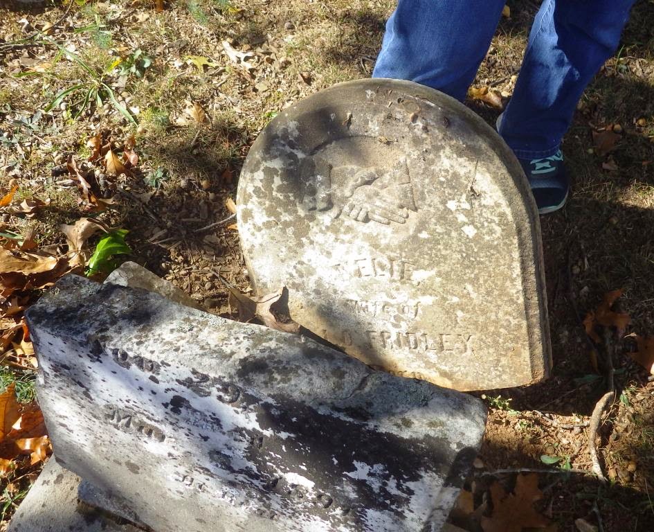
At the time, we didn't think much of it, and we didn't notice any Cornelias, or any Helmintollers or McKenneys we recognized. But Sherry double-checked that I photographed every stone, and called me back with the camera after I was ready to leave. She had found a headstone broken in half, and wanted a picture of it, so she supported the top half with her legs and I took the photo you see here.

Today, we were again reminded that Cornelia remarried after her first husband (Sherry's GG GF) died. She married a John O Fridley. And what this stone actually says is "Nelia, wife of J O Fridley". So not only did we find a picture of Sherry's Great-Great-Grandmother's tombstone, but it was a picture we took months ago without even realizing it.

Global Positioning

When Sherry and I decided to volunteer with Find-A-Grave to take pictures of gravestones, we felt that it was important that we have a record of the location where each picture was taken. Since digital cameras typically produce JPEG files, and the JPEG format can include header data with GPS location, we felt it was simplest to find a digital camera that included GPS that it would stamp onto each picture as it was taken.

It turns out this is called "GeoTagging" and is fairly common among a younger crowd. Younger than us, at least. At any rate, when we looked for GPS-enabled cameras last year, there were two kinds - GPS add-ons to expensive digital SLR cameras, and "tough" cameras. I found this whole new niche of digital cameras I didn't know existed - they are waterproof, shockproof, and geotag-ready. They even take pictures underwater!

So we got one, a Pentax model WG-3 GPS, which we've been very happy with. It takes a couple seconds from when you turn it on until it locates a GPS satellite and then every outdoor picture will be tagged. At home, I can examine the GPS tags and map where the grave location is on Google Maps.

Okay, now we know that GPS for cameras is probably only accurate to about ten feet. But even if the GPS gets you within 20 feet, it has really narrowed the area you have to search for a grave.

We leave the geotag information in the header when we upload the pictures to Find-A-Grave. On purpose.

Here's why.

I feel that the biggest next step for Find-A-Grave has to involve some kind of spatial proximity among graves. When we go to a cemetery to get genealogical information, one of the biggest ways to get information is to look at the graves around the one you already knew about. Maybe Uncle Joe is buried next to his parents. Or his children. Or the "significant other" he spent the last twenty years of his life with after his wife passed.

Find-A-Grave currently allows you to enter plot information. Sometimes this is useful, in larger, more organized, active cemeteries. For the smaller places Sherry and I frequent there isn't any plot information. Even in many of the larger cemeteries a plot number doesn't pinpoint the grave very well, unless you know all the intricacies of how to read the cemetery's cryptic markers.

Find-A-Grave also allows you to enter GPS coordinates for each memorial. This is done as an extra step. If it is a memorial you have created, you click "Add Plot" and enter the latitude and longitude from the photo, after extracting them and converting them to the right format. If the memorial was created by someone else, and you are just adding the photo, you have to send an edit request to the owner/creator of the memorial with the latitude and longitude. Probably if they notice that your name matches the photo, they will accept the edit without question. If they are still active in Find-A-Grave, of course.

Anyway, the point of the above rant is that it would be much simpler if Find-A-Grave decides to examine the GPS tags in the JPEG files themselves. They can automate the process of extracting the coordinates, converting them to the right format, and updating the location of the grave. And maybe by the time they get around to that, they will also address how to display grave positions so that their users can see what graves are nearby the grave of their loved one.

-- David, blogging from 39°08'40.4"N 77°24'45.0"W

Update, 17 Jan 2015

Find-A-Grave now has an "Upload and Transcribe" option in Beta form. You have to go to a link, http://www.findagrave.com/enable-beta, and then it shows a Transcriptions section on your member page, and on each cemetery page.

The idea is that you upload gravestone photos for a particular cemetery, and then you go in and transcribe the gravestone data directly into cemetery records. It's still Beta, so there's the occasional bug, but it seems very well done. You can enter one or more persons data for each stone, and if they already exist in the database it pulls up the existing entry. You have a week from when you upload the photos to transcribe them, and then they are released into a general pool where anyone can transcribe them.

As a side note - I've found that I still want to do a little pre-processing on the photos before I upload them. Usually I just crop the photo close to the stone, adjust the brightness/contrast, and compress.

All of that is fantastic on it's own, and a great improvement to the site. But in the spirit of this blog post, they actually pull the geotag data from the uploaded photos and attach it to the memorial records. Here's a link to one that we uploaded, and you can see the GPS info: Walter P Broyles

There's a Cemetery Photo Map link from the cemetery page, and that sounds very promising, but it doesn't seem to work yet. But as we know the GPS data is already in the system, so when they get it working it should be able to map the photos we are transcribing today.

Thank you, Find-a-Grave!

06 November 2014

Virginia Stones


Sherry wanted to research her family ties in the Alleghany County, Virginia area. She has a great-great-grandfather, John McKinney, that moved to the Rich Patch area south of Covington around 1840. He married Lucy, who was from that area, and they settled down and raised a family. About the time of the civil war, after the 1860 census, he disappeared. We haven't found a burial notice for him anywhere, so we thought we would go down in person to check a few possible spots.

So we packed up everyone in the car and headed to Virginia. The boys were intent on their video games and didn't seem to notice the drive much until we got to our first stop.

When we got to the first cemetery, the boys immediately found fields to play in and a hill to climb. So while we quickly surveyed and photographed the Johnson-Helmintoller-Plymale cemetery, the boys ran and played and had a great time. They weren't alone. When Sherry and I finished up, we went rock climbing as well.

The cemetery was well maintained and the majority of headstones were readable. We photographed the location.  The McKinney family was not against the headstones.  Our adventure continued to find the burial location of the McKinney family.


From here, we drove south, and found a church cemetery which we quickly surveyed.  We found multiple families at rest here. We took pictures and pushed forward.

Through the use of the Internet, we found another possible cemetery. We found a reference for a cemetery in Oriskany, which was in the next county over from Alleghany. It turned out to be a fabulous drive over the mountain and through the Jefferson National Forest, with many scenic views along the way.

The last part of the drive follows Craig Creek through fertile bottom land. We came into Oriskany and immediately found a cemetery right in the middle of town. We asked at the house if we were in the right place, and the owner pointed us to another cemetery down the road. We had to follow a farm road down to the swinging bridge, which sounded interesting.

We found that the road doesn't go over the bridge - it's for pedestrians only. The road crosses the creek at a shallow ford. We took it in stride, and the kids loved it. Upstream, we could see the swinging bridge, and we all eagerly anticipated exploring that adventure. But we saved that for the trip back.

The family cemetery gleamed beside an old cottage after the road crossed the ford. We dropped the boys off to run through farm fields and explore, and we checked out the what the boys referred to as the "boneyard." A quick overview revealed a family cemetery not established on the name McKinney. We consoled ourselves by mapping the 30 or so graves,.  Eventually I retrieved the boys from the cow pasture and literally dropped them in the creek.  Sherry stole off to the swinging bridge to check its safety. When the boys spotted her crossing the bridge it triggered a rush of adventure.

Sherry and the boys ran back and forth from the creek to the fields across the bridge and through the creek. The bridge was a great challenge - if you walked at more than a crawling pace, it lived up to it's name immediately.

The boys, Sherry and I, chatted excitedly about the day's activities of cliffs, swinging bridges, and creeks crossings. So much so, that the flinging of wet socks to be replaced by dry didn't elicit a "phew," or disgusted faces.

On the way home, we stopped at Pizza Hut for lunch, the boys gamed, while Sherry and I discussed the day's genealogical accomplishments.  In spite of finding little evidence of the McKinneys' final resting place (Sherry likes to point out, that we know now where they are not buried,) we had an awesome adventure!

13 September 2014

Smith's Cemetery

So about a year ago we were searching hard for a Smith's Cemetery in Fayette County. Sherry had found a record that her grandmother had a baby that died young and was buried in a Smith Cemetery in Oak Hill.

Finding Smith's

We found a death certificate that mentioned a burial in Smith Cem in Oak Hill. Tyree Funeral Home was listed as the Undertaker. They are still in business, so we called their Oak Hill office and asked about the cemetery. They gave us directions that were to go to Greentown Road, go around the big curve and find a house on the left at the top of a hill.

We drove out Greentown Road and didn't see it on the first pass, so we stopped and asked a family that was working in the yard. They said we had to go back down the road to the nice brick house, now on the right side, and the cemetery was up on the hill above the house. We still weren't quite sure where it was but we spotted it after we passed and just had to turn around and come back.

This seems to be the way we find cemeteries. We get a rough idea of where it is and what we're looking for, go to the area and have to ask for help. So far we've always found helpful people - Sherry is excellent at spotting the perfect person to help with directions.


Mapping and Photos

We found a small-ish cemetery with about 50 interments, spread out over the top of a hill, with a big oak tree in the middle. The oldest graves seemed to be closest to the house, on the east side of the hill. Then there were a bunch of graves in the middle near the tree, and a few along the treeline to the west and north. We noticed that there were a couple different family names (Smith, Olds, Evans, Hamilton, Newton, Plumley, Painter), and five or six military graves.

We knew the cemetery probably wasn't in Find-A-Grave at all, so we photographed every grave we could find. We were mostly looking for a baby's grave from 1939, and we didn't find anything marked that way. We did find a couple graves near the tree that weren't marked and seemed to be for infants, so we think that our Phillis has a home here.
It was a beautiful fall day and the leaves were starting to change. Sherry found an old wood pile, and what looked like the old sign for the cemetery lying there, so we set it up and took a picture.

Research

Some of the names interested me - Odgen instead of Ogden, Myrtha, Nellie Painter. I decided to put them in a separate Ancestry tree while Sherry was working on her own family.

These are some of the relationships we found between the families:

  • Hazel Plumley married Lana Smith in 1925.
  • John Wise Olds married Rosa Zetta Smith in 
  • Lottie Ann Elsie Evans married Jess Willard Olds in 1950.
  • Dolly Mattie Evans  married George F. Olds in 1950. Dolly & Lottie were sisters and Jess and George were brothers.
  • Harmon Smith married Verlina Hamilton, daughter of Samuel and Luella, in 1931.
  • A family of Painters lived next door to Harmon Smith's family 
Of course it turned out that Harmon Smith is in Sherry's family tree.

Links


06 September 2014

Bruebaker, Brubaker, Brubacher, Brewbaker


Family Follies

Historical Excerpts Cracking Smiles and maybe a Stone Wall


As my husband and I research newspapers for genealogical clues, we stumble across articles that urges us to explore further.  Here are a few from the Bruebaker Family research collection.


Preemptive Undertaker

The Times, Philadelphia, Pennsylvania, 13 October 1889 and Lebanon Daily News, Lancaster, PA. 14 October 1889.   This story is reported differently by two newspapers.

"His Haste Lost Him a Job"


Genealogical tags:  Victoria Brubaker, single, born about 1868, lived in Lancaster, Pa in 1889:  

W.T.S. Gable, undertaker, lived in Lancaster, PA 1889 as an adult


Both articles are full of genealogical data. The first article, though short, reports her age and that is very helpful information when trying to locate other sources.  The second article fills in the gaps of what happened, who revived her, and what followed;  which leaves the reader with less questions.  The genealogical "gold" is listing Miss Brubaker and Mr.Gable's full names.

"Found Dying on a Grave"


Genealogical tags:  Elizabeth Victoria Brubaker, adult in 1889, lived in Lancaster, PA. 

Nephew died in 1887, buried in Lancaster Cemetery, and brother lived in New York.

William Gable an adult male in 1889, living in :Lancaster, PA.


Arm Amputated

15 March 1881, Staunton Spectator, Library of Virginia, http://www.lva.virginia.gov/

"Saw Mill"

"Arm Amputated"


These are the citizens that built our nation by conquering tragedy.  Through the information in the article I was able locate Gideon E. Brubaker in Page County, Virginia, who worked as a farmer in 1870 census and worked in a postal appointment in 1899.  The 1880 census notes he has a "leg off."  Gideon was born to Gideon C. & Mary Brubaker in 1849 and died in 1926. He never gave up.

Staunton Spectator 15 March 1881 — Library of Virginia

Genealogical tags:  Gideon E. Brubaker, lived in Page County, VA,1881, born 1849, died 1926. 

Father: Gideon C. Brubaker 

Mother: Mary Brubaker        


Used with permission of Project Gutenberg License included with this eBook or online at www.gutenberg.org/license

05 September 2014

Valley View Cemetery

This is a medium-sized cemetery, about 250 interments. It's on a nicely kept hillside in the middle of Summers County. Seriously the middle - if you bring up Summers County on Google Maps and keep zooming in, you will find it. But I will save you the trouble, here it is: 37.660327, -80.806826

Finding It

This one didn't have map coordinates in Find-A-Grave, but it did have a picture of the church nearby. And the obituaries I saw all mentioned "Powley's Creek". So we found Powleys Creek Road and located the church and cemetery on Google Earth and planned our trip.

The drive down to Hinton and out along the Greenbrier is very nice. Both our families used to travel it pretty often, since when I was growing up (and Sherry was a baby) it was the main route to the East until you could connect up to I-64 at Sam Black Church or Alta.

As we approached the start of Powley's Creek Road, Sherry said to pay attention to the tunnel. You couldn't see the tunnel until you were right on it, and I have no idea how she knew it was there, but we found it and made the turn up the road. The tunnel is about 60 feet long, and Sherry got some nice pictures from the inside.

We continued up the road and found the church and the cemetery right where we expected. The scenic beauty of the place is breathtaking.

Photographing

We started our usual process. We had thirteen photo requests to look for, and since the cemetery was only about 40% photographed, we decided to get as many photos as we could. Taking the photos is pretty easy, especially for upright stones in good condition.

Sherry went and chatted with a man who was clearing a downed tree from the field. He said his friend took care of keeping the cemetery mowed, which we appreciated.

We stopped off at Kirks on the way home for ice cream and a snack. The boys enjoy watching the ducks swim on the river.

Links

01 September 2014

Reed Cemetery

Reed Cemetery

Far down the C&O Dam Road in Daniels is the well-maintained Reed (or maybe Reed/Smith) Cemetery. It is a small cemetery (about 30 interments) with 3 family names - Reed, Smith and Lilly. The reports are that Dr. James used to own the land, and lived in a 2-story farmhouse below the cemetery. The farmhouse is gone now, but the view from the cemetery is serene and beautiful.

Finding the place

We received photo requests for the cemetery (from Ralph), but not a specific location. Ralph found death certificates of his family that listed the funeral home. I emailed to request the cemetery's location, and they replied timely with the following:
The information we have on Reed Cemetery is that it is located off C & O Dam Road in Daniels, WV, near the Boy Scouts Camp.  Before you get to the camp, turn back to the left and go about a quarter mile, turn beside Dr. James' two-story farmhouse on the right.  Cemetery sits upon the hill behind the farm.  Unfortunately, there is no other direction or contact information on file.    Good luck!
We got to the scout camp easily enough, I (David) remembered it from my scouting days. We hunted among the houses around there for a while without luck. I was about to give up, but Sherry wanted to try going past the scout camp, and I have learned to trust her intuition. We went another mile or so to where you cross the turnpike to stay on the C&O Dam Road.

At that point, Sherry spied a group of folks preparing to take their BBQ/Gyro wagons to a fair. We were directed to the head of the group with our questions. He immediately recognized the description of his neighbor's property. He remembered a pond he use to fish near the cemetery, and the occasion that his cows wandered onto the his neighbor's field, and Dr. James kindly assisted him in herding the cows home. He pointed us further down C & O Dam Road away from the Boy Scout Camp. He said there use to be a bird sanctuary sign. How fortunate we were to approach the neighbor that actually had interactions with Dr. James and knew of the cemetery. Later we realized the cemetery was well inside the property and not view-able from the main road and without his assistance.

We didn't find the bird sanctuary, but we did eventually figure out that Belwood Lane was the correct turnoff.  After maneuvering the dirt lane over a half mile, I saw the cemetery, or rather, I saw a flag post and a fenced area at the top of a knoll and knew we found our cemetery!  We went on to the end of the road and talked to a neighbor, seeking permission to explore the cemetery. Without hesitation, he directed us to a nice, well-maintained path up to the top.

We were so excited to find the site, we parked at the bottom of the field and walked up through the tall grass full of  purple blooming wildflowers. When we arrived at the top, we saw the gate was on the other side.  We followed fence having to crawl under some rusted old strands of barbed wire that connected perpendicularly to the outside of the cemetery's fence. We both chuckled and said, "cow diversion tactic." As we pulled brown thorny "hitchhikers" from our clothes, we noted the well maintained path that we could easily navigate in our little Honda.  However, we enjoyed following the deer trail from the pond covered in vegetation to the flag seen at the top of a hill beaconing the position of the cemetery.

Photographing

We started our normal process - I go through the place systematically while Sherry pinpoints the whereabouts of any photo requests and noting possible relationships.  She also likes to take artistic photos of the surrounding scenery and plant life with a whimsical eye. We also note any family buried away from the family in a corner or outside a fence, which is a great clue to the family history. Also, we are careful not to post a picture or information on a family member without a death date.  With family cemeteries we like to digitally record all the headstones.  Later we complete an internet and vital statistics search to create a family tree.  We post the family tree as a public tree on Ancestry.com. We use a camera with GPS so that the photos are pinpointed to a location.

Inevitably we find head stones that are unreadable.  Sherry will urge me to help her read the eroded, lichen-covered words to try to preserve the information.  If unsuccessful, we audio record what is readable and take a digital picture. Occasionally someone will know who was buried there. Once we return home we try to elicit the information from the pictures using digital enhancement then confirmation with a death certificate, vital record, etc.

Unlabeled Graves

This cemetery has seven or eight graves with markers but no labeling. If you know who these graves might belong to, please contact us.

Links

If you want to see the Find-A-Grave records for this cemetery, here is the link:

We setup a public tree on Ancestry for the Reed family, which is listed as "Reed Cemetery Tree". From a quick search on Elias Reed, it looks like there are a bunch of other public trees that will tie into it.

Breaking the Stone Family Genealogical Roadblock Broken


Copyright Slowmoto Graphics 2014

EDWARD HENRY MYERS – FAMILY GENEALOGICAL ROADBLOCK

Edward H. Myers was married to my great grandmother Almedia Wright in 1895. He disappeared before 1900, according to the 1900 census and the 1903 divorce initiated by Almedia for abandonment. He is not a direct relative to me but it did intrigue me. Almedia married James Bruebaker and then after my grandmother was born, she disappeared as well. My husband and I have searched a clue about Edward's life after he left for the last five years.

Recently I reviewed the records we did know belonged to Edward, including his marriage certificate to Almedia. From this record, we felt reasonably secure that he matched the 1880 census record with matching parents and a location of Franklin, Pennsylvania. We traced his parents and siblings without success. We were hoping we would find him in a later census with a sibling or parent.

From the divorce record, Almedia (Medie) suspected he went out west. She stated in the divorce record on Library of Virginia (chancery archives, index number 1903-070) that he left in 1898 and was staying in Arkansas. So I started looking at Find-A-Grave, FamilySearch, Fold3, LVA.virginia.gov, Ancestry.com, for death records, marriage records, census, church records, drafts registrations, military records, state archives, and prison records anywhere past the Mississippi. We entered his name into Newspapers.com in multiple variations and spellings looking for articles with his name. We also searched for records not online. On Find-A-Grave I found a grave stone, with a close birth date and matching middle initial.

Still searching, a death certificate surfaced for an Edward Mires uploaded by another member of Ancestry.com. The death certificate was for Edward Henry Mires and his parents were transcribed as George Myers and Sarral Avert. Could Edward Henry Mires and Edward H. Myers be the same person? The “Edward H. Myers” I was researching was born to George Myers and Sarah West in Pennsylvania. I looked closer at the death certificate and wow, it looked like Sarah A West, not Avest. This matched the 1880 census, his marriage certificate to Almedia, and now, his death record.

Edward's second wife, Ollie Thacker was born in Wise County, the last known whereabouts of Edward H. Myers. Ollie Thacker is a resident there per the 1896 Wise County School census. She was not in 1900 census and neither was Edward Myers, in Wise County, (or any other 1900 census as of date.) Edward Myers’ first wife was living with her mom, Margaret Wright, in Wise County with two children, Ethel and Alfred. Ollie was an orphan and was thought to have been placed on an Orphan Train that ended up in Idaho. We continue to search for Edward and Ollie in the 1900 census either together or apart and a marriage certificate. The 1910 census reports them being married 10 years.
Both, Edward and Ollie resurfaced in the 1910 census with their son Jess “Jessifer” Myers in Colorado. Jess was documented as being born in Arkansas. Jess served time in prison in Colorado. Later, he married Gertrude Fletcher and had a son Donald. Edward and Ollie had a second son, Eugene Earl Myers in 1912. He was a marine and died by friendly fire.

Eventually we did find information that her grandson Donald lived with his parents, Jess and Gertrude in Idaho during Ollie’s lifetime thus inferring that she may have lived there as well which gives credence to the documentation of Ollie being referred to as “Idaho Ollie,” by her brother, when she would later visit him back in Virginia. Donald Myers married overseas to a girl from London and brought his wife back to the states.

Edward Henry Myers died in 1918 during the Flu Epidemic. Eugene Earl Myers, his son, was eventually buried beside him.

What an amazing feeling of success to finally break the stone that collapsed a genealogical roadblock! We have re-examined records and tried to poke holes in the research. We noted that if any record was missing then the other records would be uncertain. However, when looking at the records as a whole, the theory seems to be more of a reality. We continue to search and confirm findings. We requested photos on Find-A-Grave for his wife and family members. We are searching for a relative that is still living to reconnect.

The Edward Henry Myers Tree, a working project, is on ancestry.com as a public tree. If you have any information, questions, or concerns, please send us an email or message.


31 August 2014

Small World

Jumping Branch Coincidence

We went to a cemetery in Daniels WV this weekend to look for some Lilly graves. It was a small cemetery with about 30 graves - mostly Reeds, Smiths and Lillys. We photographed them all, and I uploaded the Lilly ones that were requested, and I started looking at the others.

When I look at a family cemetery like this, I like to lookup some additional data, birth and death records if the date ranges are right and so on. (West Virginia's wvculture.org/vrr site is great for this, by the way). And if there's enough there, I start an Ancestry tree to help look for census data and other records.

I started with Elias Reed. From the stones I know that I at least have info on his wife and daughter. I found an 1880 census record, and then an 1870 record, both in Slab Fork. We're always coaching each other to look at the actual records, so I pulled up the 1870 record and stared at it for a while. Eventually I scrolled down and looked at the neighbors of Elias Reed. I got a serious shock to find out that they were Numa and Martha Walker, my wife's great-great-grandparents.

Every cemetery we visit in Raleigh County we've found family names from my wife's tree. This one took a little more digging.